
First Colonial Settlement
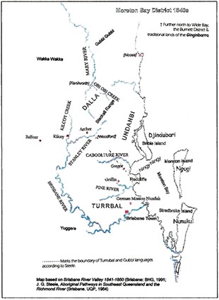
The indigenous people of the Brisbane River Valley recorded their cultural history in the choice of totems, the physical boundaries that determined their language groups, rites of passage through these boundaries, complex social and sacred ceremonials, their social regulation, retribution for transgressions and their “stories” in both oral and pictorial form.
But sadly for the Europeans who came later, few of them recorded the old indigenous history. Fewer still had the training to interpret the old stories in any other way than through their own ‘world view’. Thomas Petrie seems to have been a notable exception. He grew up with aboriginal children in the Brisbane district from 1837 to 1844 and spoke their language (Turrabul). His stories about the passage of various groups through each other’s territory to the triennial Bunya feast he attended with his aboriginal friends in 1844 have passed into colonial history (Tom Petrie’s Reminiscences of Early Queensland by C.C. Petrie (ed), 1904).
The simplest link between indigenous history and colonial history is the mapping of the Brisbane River. It had served as a boundary between the Jaggera and the Turrbal people and it had been shown to two lost convicts (Thomas Pamphlett and John Finnegan) whom John Oxley rescued in Moreton Bay in 1823.
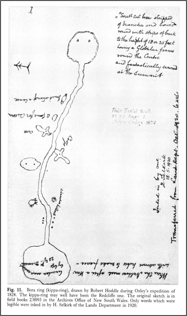
Finnegan finally lead Oxley to the Brisbane River after leading him by mistake up the Pine River almost to Petrie. Oxley returned to survey Red Cliffe as the Moreton Bay penal colony, but left Robert Hoddle to do this while he further explored the Brisbane River. And just as well that he did, for Hoddle has left some quite detailed drawing of local kippa- and bora rings from 1824.
By 1825 the colony site had been changed to one on the Brisbane River, and Pilot John Gray came to buoy the Pumicestone Passage. He reported a tribe of white men with bows and arrows on the Brisbane River near Fernvale, and Edmund Lockyer was sent to verify this in 1826. When he failed to do so, he recorded the site of Fernvale on his map as Grey’s Mistake. Lockyer did, however, find Mt. Brisbane.
The infamous Commandant Logan arrived in 1826 and discovered the Logan River and explored the Bremer River to Ipswich. Two years later, Alan Cunningham found Cunningham’s Gap that would link the Darling Downs to the Moreton Bay port, and the following year he climbed Mt. Esk, cut across a distinctive loop in the Brisbane River he called Pedal Bight (near Wivenhoe), crossed Lockyer’s Plains (Cressbrook) and climbed Lister’s Peak 2 miles south east of Linville.
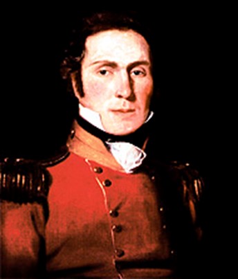
On his last exploration in 1830, Patrick Logan (right) travelled up the Brisbane River, explored part of the Stanley River and probably Kilcoy Creek as well. He was killed on 17 October near the original site of Bellevue station on the ‘Pedal Bight’ and was not found until several days later. Controversy still surrounds his death and his cruel and ruthless behavior is now legendary but he had contributed significantly to the knowledge of Moreton Bay during his watch.
The convict colony of Moreton Bay was closed in 1839 and surveyors were sent in to survey the district for settlement. And a motley lot they were too! James Warner immediately became shipwrecked surveying the coast line between Moreton Bay and the Richmond River. Granville Stapylton, grandson of the fourth Viscount Chetwynd and a public drunkard, was killed along with his assistant by aboriginals while surveying in the Mt. Lindsay area of Beaudesert. Robert Dixon was charged with inciting a mutiny and was suspended from duty in 1840. He promptly used the data from the Surveyor General’s office and published under his own hand the first map of Moreton Bay available in England. A later map (1846) by Dixon shows the pastoral developments already established and the ‘roads’ connecting them.
Before Lieutenant Owen Gorman left Moreton Bay he had found a more practicable Gap in the Range linking the Darling Downs with Ipswich and Brisbane, and it was through this Gorman’s Gap that the early settlers of the Brisbane Valley brought their stock. They came down the Range, along Lockyer Creek past Grantham, Tent-Hill and Helidon selections to Tarampa and then north along the Brisbane River to their selections. Initially they established Cressbrook (McConnels), Durundur (Archers), Kilcoy (MacKenzie), Mt. Brisbane (Bigges), then Colinton (Balfours) and Eskdale (Graham & Ivory), and later River Station (Ferriter & Uhr), Mt. Esk (Scotts) & Fairney Law (North).
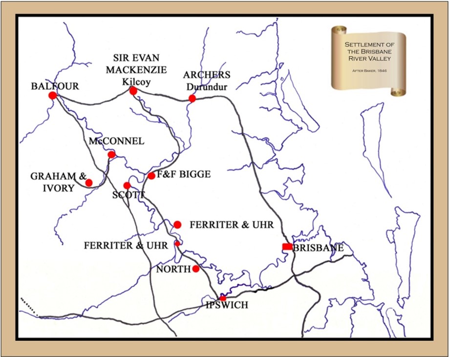
Some, like the McConnels, settled well and stayed. Others, like the Archers, moved on to explore further north and settle at Emu Creek, Cooyar, Eidsvold and Gracemere, discovering the Fitzroy River on which Rockhampton now stands in their travels. Borthwick & Oliver, who had selected Buaraba in the Brisbane Valley also moved north to select Tarong and Nanango stations. By 1847 Borthwick’s neighbours at Tarong on Barambah Creek were Ferritur & Uhr who had also left Wivenhoe (River Run) after John Uhr was killed there on Christmas day 1845. Tarong’s manager was George Clapperton who had also worked on Nanango station, and later bought Tarong from Borthwick. The Clapperton’s settled and Tarong, like Cressbrook, remains in the same family hands today. Alexander & Gideon Scott sold Mt. Esk to the Bigge’s and Alexander Scott went north with his nephew Simon Scott to Taromeo. The Scotts also remained for generations.